
Recently, the Government of India launched 100 Indian made agricultural drones during one of the largest collective drone exercises in the country. Earlier, the Drone Shakti initiative was announced in the Union Budget 2002 to commercialise drone applications through drones-as-a-service (DRaaS) model. This is further to India already taking several steps to encourage drone usage in agriculture. These include a drone certification program, a subsidy scheme for usage of drones in agriculture, and a contingency fund to help farmers access drones at low cost. The Indian government has also started the process of mapping six lakh villages using drones and geospatial technology.
In response, many industrialists have declared their intentions to scale up manufacture of farm drones. India is home to more than 150 drone start-ups – many of these are considering playing a bigger role in agriculture. A Chennai-based drone start-up has committed to manufacture six lakh kisan drones by 2025.
What is an Agricultural Drone?
An agricultural drone is a special purpose UAV (unmanned aerial vehicle) that is designed to monitor crop production by tracking crop growth and soil conditions in real-time. This approach is part of a larger practice known as “Precision Agriculture” which aims to maximise farm productivity, quality and yield by optimising usage of water and fertiliser with effective pest control and disease management. The multispectral sensors used in such drones can capture data from the reflected light energy within several bands across the electromagnetic spectrum – including visible, near infrared, and short-wave infrared wavelengths.
Why Agricultural Drone?
Globally, up to 40 percent of crops are lost to pests, as per an estimate by United Nations’ Food and Agriculture Organization (FAO). Plant diseases make a dent of about $220 billion to the global economy and insects cause damages of about US$70 billion. There are many other pressures in the entire farm-to-fork supply chain – for example, increasing costs, traceability requirements and climate crisis needs.
These pressures have been pushing the world towards adopting sustainable agriculture practices and deploying precision agriculture technologies. Use of UAVs offer significant benefits – surveying tough terrains, recording high resolution images and faster monitoring of large regions in a short time. The potential of drone-based applications is magnifying with increasing sophistication of UAVs and convergence with technologies like AI, Big Data and IoT. This seems to be the perfect time to scale-up manufacture of agriculture drones in India.
How do Drone Applications work in Agriculture?
Precise gathering, processing and analysis of farm data in real-time is made possible by a combination of technologies like global positioning system (GPS), geographic information system (GIS) and advanced AI (artificial intelligence) software.
Land Mapping / Surveying: The first step is to conduct an aerial survey to map the specific areas that need to be monitored using flight planning software. This software helps create an automated flight path during which camera shots are taken from different angles and each image is tagged with specific coordinates. This process compiles comprehensive data across multiple parameters and is several times faster than regular land-based methods.
Soil Analysis: Tracking various soil quality indicators throughout the year is a critical part of any farming operation. Drones are well suited to automate this process all year round to achieve proactive soil monitoring, preventing soil erosion, timely nutrient replacement and preparing soil for seasonal rotation. Multispectral imaging sensors capture unique light wavelengths of different soil conditions to assist AI-driven software to accurately assess soil elements.
Planting and Seeding: Drones are being increasingly used for large-scale seed planting as the UAVs provide exhaustive data on various parameters related to climate, soil and terrain. This is a big opportunity for rapidly dealing with climate change as complete reforestation can be quickly done using automated drone seeders. This is especially useful in difficult terrains where manual plantation may not be safe for workers. A drone-based tree plantation done in Telangana using local drones resulted in a 10-fold reduction in cost of reforestation with the added benefit of covering large areas in less time with absolutely no danger to workers. The domestic company has been further roped into plant 50 lakh seeds on 12,000 hectares across all districts of Telangana.
Irrigation Monitoring and Planning: Microwave sensing and related technologies can help accurately assess moisture levels in the soil. This leads to highly efficient distribution of water across the crops. In addition, drones can monitor drainage patterns and identify irrigation leakages leading to conservation of precious water.
Monitoring Crop Health: Images captured by drones provide valuable data on crop growth, density and other parameters like colouration and any signs of disease. Researchers at International Institute of Information Technology (IIIT) Naya Raipur have developed a drone-based crop health forecasting solution that uses AI to proactively detect pests and diseases and suggest quick and accurate remedies.
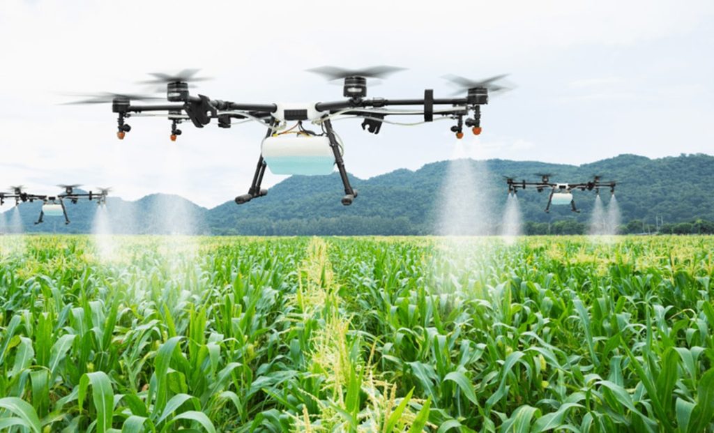
Crop Spraying: Using drones to spray insecticides and fertilisers helps automate the process of crop protection. The Rajasthan state government is working on an action plan to use drones for spraying of chemicals and water-soluble fertilisers. An exercise was conducted near Jaipur to demonstrate how one acre of land can be sprayed in about 10 minutes. This is a highly efficient process as drones can move around quickly while avoiding obstructions using sensors and the mist spray technology covers every area of the crop.
Crop Damage Management: Recording data related to crop damage due to pests, diseases, weeds, floods and other causes is a very critical exercise. Early detection of damage can help minimise losses and assist farmers in reclaiming damaged areas quickly. During disasters, automated damage assessment can speed up the process of insurance claims.
Livestock Management: Tracking livestock movement through drones can help detect sick animals and prevent their straying into areas that could harm them or damage the crops. Interestingly, a drone can even be used to herd cattle – the noise made by a drone hovering over a herd keeps them moving.
Introducing the India Kisan Drone
With an objective to boost the agriculture sector in the country by promoting crop assessment, digitization of land records and spraying of insecticides and nutrients uniformly. With an estimated capacity of 5-10kg, the Kisan drone would be highly efficient – spraying one acre of land in under 15 minutes.
A ‘game changer’ element would be the shipment of fresh farm produce like vegetables, fruits and fish directly to the markets. This would bring huge efficiency in the farm-to-fork supply chain as the produce would reach the consumer faster in fresh condition with minimum damage. Naturally, the profits to farmers would increase and the consumers would be happier.
While India is among the largest agricultural economies in the world, its agricultural yield is lower than other large agricultural producers like Brazil, China and USA. Crop damage, inefficient irrigation and improper use of soil nutrients are some of the factors that impact farm yields. Extremely high levels of water consumption have resulted in severe depletion of groundwater in India. The climate crisis has put additional pressure on the agricultural ecosystem. Drones can play a significant role in tackling all these challenges. There is an urgent need and a great opportunity to deploy the latest drone-based technologies to help create a big leap in India’s agricultural yield. It is estimated that drones can increase agriculture GDP by 1-1.5%. Time has come for the Indian agrarian ecosystem to shed off its network of inefficiencies and allow the farmers to achieve higher profits sustainably with the aid of agricultural drones.